
Understanding tidal streams and heights is essential for passage planning and safe navigation. The RYA's former chief examiner, James Stevens, explains how
I resolved to learn how to calculate tidal heights accurately on one of my first trips as skipper, after a miserable few hours aground and leaning over at anchor in the Tréguier river in north Brittany, writes James Stevens.
Fortunately, the yacht was unscathed, but it served as a strong reminder of the importance of getting the numbers right.
The RYA uses the Admiralty method of calculating tidal heights. It’s quite slow and complicated, particularly for secondary ports, but it’s accurate and can be applied anywhere in the world.
Tidal height calculations answer one of two problems.
- How high? I know the time, but I need to know the height of the tide.
- When? I know the height I need, but when will the tide reach that level?
A common reason for working out the height is the necessity to know the minimum depth in which to anchor or moor in order to ensure but when will the tide reach that level?
A common reason for working out the height is the necessity to know the minimum depth in which to anchor or moor to ensure the boat stays afloat at low water – the problem I had in Tréguier.
In fact, as skipper, you should have at least an estimate of this every time you enter a port.

Preparation is vital for tidal races such as this one off St Alban’s Head. This yacht is making the most of the strong tide, just outside the disturbed water. Credit: Julian Peckham
It’s a regular question on Yachtmaster exams and also in the RYA shore-based papers – at least it was when I wrote them.
Many candidates struggle with this question because they bring chart datum into the calculation.
You don’t have to. The numbers you need are: the amount the tide will drop to low water, the draught of the yacht, and whatever safety margin you want under the keel when the tide is at its lowest.
Say the range of the tide today is 5.0m, and you arrive, to make life simple, at half tide.
The tide will drop 2.5m to low water. If the draught of the yacht is 2.0m and you give yourself 0.5m safety at low water, the minimum depth to moor when you arrive is 2.5 + 2.0 + 0.5, which I make 5.0. Simply wander about until you find a mooring or anchorage in at least 5.0m, and you will then stay afloat at low water (see below).

For the second type of tidal question, you need to be able to work out when the tide will reach a certain level, particularly if you are venturing onto the green parts of the Admiralty chart – which you probably will do during the exam.
For tidal calculations, an accurate height is more important than the time. It’s hardly worth correcting for 10 minutes for a secondary port, but 0.3m can be the difference between being inside or outside a harbour sill.
Calculating tidal heights accurately opens up a whole new area of yachting.
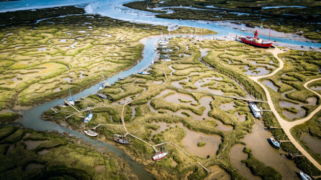
On days when the weather is too severe to venture to sea or even when it is windless, a river trip or visit to a drying harbour is a really worthwhile adventure.
The British coast abounds with interesting and unusual harbours which are accessible by yacht skippers who have done the calculations.
The Admiralty method of calculating secondary tidal heights gives you the corrections to apply to the standard port for MHWS, MHWN, and also MLWS and MLWN. For example, for Braye in the Channel Islands, the standard port is St Helier.

Many harbours have sills which you need to plan to cross safely. Even when you’ve done your sums, pay attention to tide gauges! This is St Malo. Credit: Sarah Norbury
If you happen to turn up on a spring tide and the height of HW at St Helier that day is 11.0 then it is very simple to work out that HW Braye is 11.0 – 4.8, which is 6.2m.
In between Springs and Neaps you have to apply a correction between -4.8 and -3.4, so you need to know how ‘springy’ the tide is: that is, whether it’s close to Springs or Neaps or halfway between.
With a bit of practice, you can interpolate by eye.
For example, if the tidal height in St Helier is 9.0, that’s about a third up from Neaps. The correction would be a third up from 3.4 to 4.8, which is about 3.8. So HW Braye is 9.0 – 3.8, which is 5.2m.
With a bit of practice, you can do this without a pencil and estimate the correction to 0.1 either way, which is good enough for most navigational problems.
You can use a similar interpolation to obtain the time of high water. It is of more use to obtain a quick and approximate value than to become bogged down in calculations while trying to skipper a yacht at the same time.
Don’t forget that while heights of lighthouses and other shore objects are measured from MHWS, clearances are now measured from the Highest Astronomical Tide (HAT).
Tidal streams
You need to be able to look up tidal streams from both the tidal diamonds on the chart and the tidal stream atlas. The exam will nearly always include an estimated position or course to steer.
Without an accurate tidal stream, these triangles don’t work at all. Revise the course to steer: a surprising number of candidates ‘join the dots’ – connecting the end of the tidal vector to the destination.
If that means nothing to you, then check the method in the RYA Navigation manual.
You are likely to be asked about tides on longer passages which might include a tidal gate.

You need to be able to look up tidal streams from the tidal diamonds on the chart and the tidal stream atlas.
Planning a passage to make best use of tides is quite an art for a sailing yacht, where the speed is constantly changing.
The examiner will expect you to have done this for real and understand the importance, for example, of arriving at the Alderney Race with a favourable tidal stream.
Sailing navigators need to understand the value of lee-bowing the tide when close-hauled.
I can recall meeting a skipper in Cherbourg whose 24-hour trip to windward from Poole was an epic in weather-bowing.
His route had taken him almost from Dover to Penzance. If he had lee-bowed the tide, he’d have travelled almost straight there in 12 hours.
Marinas and Moorings
Good boat handlers look at the tidal stream closely before attempting any manoeuvre.
The tidal stream atlas is good for planning, but on the day at the mooring, it’s observation which counts.

Correct tidal planning and understanding tidal streams and heights are the difference between a fast passage and standing still – especially somewhere like The Swinge in the Channel Islands. Credit: Sarah Norbury
For most boat handling, the tide is the strongest factor, so alongside and moorings should be attempted head to tide, with the mainsail dropped if necessary.
Good navigators use transits to cross a tide in pilotage waters, arriving by the quickest route.
Pointing to the destination and describing an arc is inefficient and slow.
A depressing trait of inexperienced skippers is to allow the yacht to be swept past the destination while lowering sails and preparing fenders and warps.
Tedious motoring against the tide follows

Why you should still make a passage plan
Cruising guide author Robert Bailey explains the importance of not being completely dependent on electronic chartplotters and why it is…

How to reef – expert advice from PBO Sail Clinic
How do you ensure an efficient reef with a roller-reefing headsail and slab-reefing mainsail? David Harding explains
Marina boat manoeuvring: reversing the roles
When couples sail together, one usually takes the lead when it comes to marina boat manoeuvring, remaining on the helm,…

Broaching on a boat and how to prevent it
When the breeze picks up, how do you stop your boat taking charge and going where it wants? David Harding…
Want to read more seamanship articles like Understanding tidal streams and heights?

A subscription to Practical Boat Owner magazine costs around 40% less than the cover price.
Print and digital editions are available through Magazines Direct – where you can also find the latest deals.
PBO is packed with information to help you get the most from boat ownership – whether sail or power.
-
-
-
- Take your DIY skills to the next level with trusted advice on boat maintenance and repairs
- Impartial, in-depth gear reviews
- Practical cruising tips for making the most of your time afloat
-
-
Follow us on Facebook, Instagram, TikTok and Twitter