Ali Wood recalls her first sailing passage using electronic charts
When I took delivery of PBO Project Boat Maximus, I used electronic charts for the first time, but only in combination with paper charts.
It had been two decades since I’d studied my RYA Yachtmaster theory, and I wanted to be sure I could adequately read a paper chart before getting to grips with electronic plotting!
For the voyage from Chichester to Poole, the first thing I did was work out the total distance and our average boat speed for the Maxi 84. This would give me the rough time it would take (tides would come later).
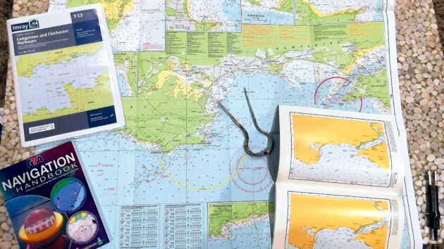
Using Imray charts and a pair of dividers I counted 47 miles, which I sense-checked against the distance tables in the Almanac.
With a winter passage and dwindling daylight hours, I decided to do the voyage over two days, with a stopover in Yarmouth, Isle of Wight. This allowed me to choose favourable west-going tides.
Once I knew what time high water was, I could check the strength of the tidal stream in the Admiralty Tidal StreamAtlas or the PBO Small Craft Almanac.

AIS overlaid on a Lighthouse nautical chart on the Raymarine Element S7 MFD. This proved to be invaluable in the busy shipping lanes of the Solent. Photo: Ali Wood.
It wasn’t just about the tides, though, I had other factors to consider, such as the winter bridge opening times in Poole and the current at the harbour entrance.
Having plotted my route on Imray’s glorious new-smelling charts, I decided to compare my hand-crafted route to that calculated by the Navionics app on a tablet.
Electronic charts for passage planning
I found it very easy to plot a course both manually and automatically.
You simply enter your boat’s draught, circle your start and finish waypoints by pressing down your finger, and bingo, it does it all for you, correctly following the buoyage.
I also requested tidal data, and it gave me actual tidal heights (as opposed to chart datum) at any given time of the day, which I scrolled through with a swipe of the finger. Wow; several hours’ work on paper condensed to five minutes on chartplotting software!

Refurbished Maximus’s ‘maiden voyage’ deliver trip. Photo: Ali Wood.
Note, though, that the route Navionics gave me was over-cautious.
In reality, had we followed this course, we’d have added hours to the voyage by taking unnecessarily long routes around lateral marks, when there was actually sufficient water to sail the rhumb line.
So having sufficient navigation skills (albeit rusty) to plot on paper, or manually programme the electronic charts, was still very useful.
The problem with the tablet when I took it on board was I couldn’t see a thing! It wasn’t daylight viewable.
While we took it to the pub the first night for passage planning over a pie and pint, we hardly used it on passage, and instead reprogrammed the route onto Lighthouse electronic charts on our Raymarine Element 7in multifunction display.
The Lighthouse electronic charts were excellent and the chartplotter fairly intuitive. The bigger challenge had been downloading the electronic charts the night before from the Charts Manager app onto a blank SD card.

I had to consider bridge opening times as part of passage planning from Chichester to Poole. Photo: Ali Wood.
Using electronic charts on the water
At sea, I soon got the hang of using the chartplotter, though I did frequently pop down below to check the paper charts for a more zoomed-out view. I found this was quicker than continually pushing buttons on a 7in screen.
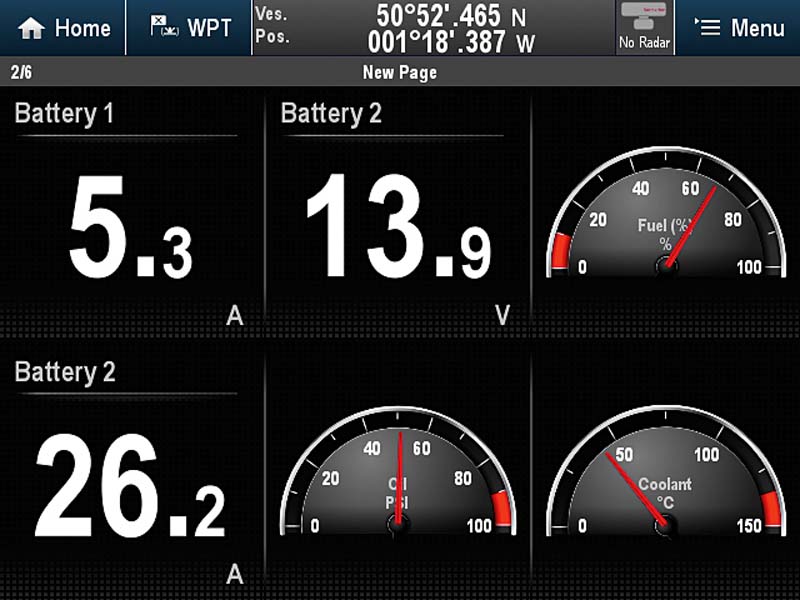
A fantastic feature of the MFD was that I could have AIS overlaid on the electronic charts.
The signal itself came from the Raymarine Ray73 radio (with built-in VHF, DSC AIS), but because we had NMEA 2000, our electronics could talk to each other. In the Solent, we could see the names of the ships coming and going and quickly know if we were on a collision course.
The MFD had a keypad, rather than touch-screen, which took a bit of getting used to. Not being able to ‘pinch-zoom’ did make it seem much slower now we’re all rather impatient and accustomed to using that feature on smartphones.

When our alternator stopped working we returned to using paper charts. Always have a backup! Photo: Ali Wood.
Note though that Raymarine’s Axiom chartplotters (the next series up) do offer the more intuitive touch-screen/ pinch-zoom operation, and you can still switch back to keypad control when seas are rough – a feature it calls HybridTouch.
While it was great to have an electronic ‘close-up’ of where we were going, and I was happy to use electronic charts as my primary means of navigation, I still regularly reached for the paper chart (protected by a waterproof case) to give me a quick bird’s eye view.
Unfortunately, on the second day of our voyage, the engine alternator stopped working and we quickly lost battery charge! While its subsequent refurbishment and replacement made a good article for PBO, it was bad news for the voyage.
To conserve power, not only did we have to turn off the chartplotter, but the autopilot too, and we were back to using paper charts anyway!

Adjusting the settings on our Raymarine plotter. Photo: Ali Wood.
The verdict
Personally, I feel sad that UKHO is phasing out paper charts, but it’s inevitable; producing them is not commercially viable when most people prefer electronic charts.
Paper charts have been an important part of my sailing life. My dad is no longer able to sail, so I recently passed on his vast collection of charts to a friend doing her RYA Yachtmaster course… but not before framing the much-loved (and feared) Swellies in North Wales!
I allowed myself a wobbly five minutes to read my dad’s beautiful handwritten annotations and trace the voyages we did together, still evident in the pencil lines taking us from Brighton to Conwy one summer on a GK24.
I remember 5am starts in heavy fog, plotting nervously and frequently on the chart, and then the relief at emerging suddenly into warm sunshine, and spotting the very landmark I’d marked in my pilotage notes – a lighthouse or peninsula, for example. Happy times.
It’s fair to say I won’t be framing screengrabs of my electronic passages… they just don’t cut it!

DIY chartplotter for £200: how to build one at home
John Calton builds his own 10in touchscreen DIY chartplotter with GPS and AIS for a fraction of the cost of…

Best chartplotters: new MFDs that every boat owner should consider
One of the best ways to choose new marine electronics is to get your hands on kit from a range…

What chartplotters can do that your smartphone can’t
A few years ago I felt there was a risk that marine electronics manufacturers would find it impossible to compete…
How to convert analogue engine data and battery levels to show on your chartplotter
Just about every engine installed in a yacht or power boat has some degree of instrumentation, ranging from the basic…
Want to read more articles like this feature on electronic charts?

A subscription to Practical Boat Owner magazine costs around 40% less than the cover price.
Print and digital editions are available through Magazines Direct – where you can also find the latest deals.
PBO is packed with information to help you get the most from boat ownership – whether sail or power.
-
-
-
- Take your DIY skills to the next level with trusted advice on boat maintenance and repairs
- Impartial, in-depth gear reviews
- Practical cruising tips for making the most of your time afloat
-
-
Follow us on Facebook, Instagram, TikTok and Twitter