Celestial navigation instructor Paul Jones gets to grips with electronic navigation – and now he's "out of the fog and into the future."

Sailing the diminutive Cal 20 in a fog bank past the Golden Gate, we started to feel the boat rise. Using eyeball navigation, we had tacked into the ground swell of the notorious Four Fathom Bank.
Like some sort of giant, it lifted the hull and suddenly the little sailboat seemed very small to the three of us who had ventured out for the first time into the Pacific Ocean.
Four Fathom, known locally as the ‘potato patch shoal’ for its proclivity of rolling ships in the bygone era to the point of dumping potatoes from baskets out through the scuppers, was merciful that day.
Ignorant of its dangers and unaware of where we were exactly, we rode the aquatic rollercoasters for a few minutes, then swung the boat east and went wing-on-wing back into the bay.
We were happy to make it home safely.
The only navigation components on board were clip-on nav lights powered by D-cell batteries.
A back-up kerosene lamp was stowed somewhere below.
That was 1970. After an elementary course in boating safety offered by the US Coast Guard Auxiliary, I decided to take a celestial navigation class.
It wasn’t a logical progression, but it matched my naive aspirations. Our instructor, a master mariner with decades of experience, passed on a lot of valuable advice, not a lick of it based on electronics.
He imparted in me a lifelong love of celestial navigation.
I started teaching it close to 30 years ago – right when modern electronic navigation was coming to the fore.
And I still love teaching it.
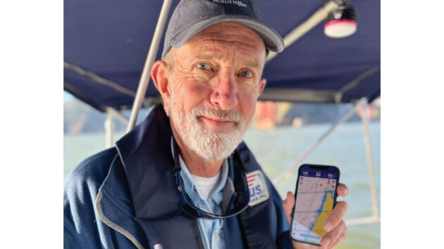
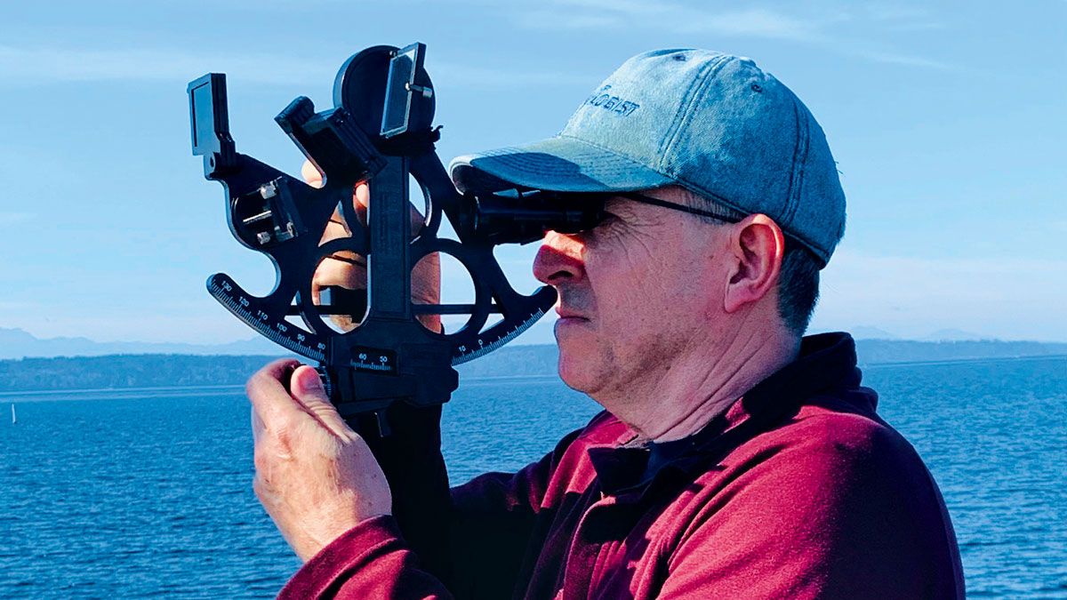
Paul now embraces electronic navigation as well as paper charts and traditional means
Testing times pre-electronic navigation
In 1973, I went to France where I ended up working at a sailing school after taking their basic two-week course in Brittany.
Their boats had no engines, so no electronics there either.
For two seasons we used nothing more than a ship’s compass, paper charts, a hand-bearing compass, and a lead line to navigate the rocky coasts, characterised by strong currents and huge tidal exchanges.
During one perilous foggy passage up the Chenal du Four just east of Ouessant (Ushant) island with seven of us were crammed into a 21ft ‘Mousquetaire’, the wind suddenly died.

View of Ouessant (Ushant) island coast on a foggy day, France. Credit: deadlyphoto.com/Alamy
The only thing we could do was drop a small grapnel anchor on 300ft of paracord to keep from drifting out into the middle of the channel, or, equally terrifying, onto the rocks scattered all around.
The thump-thump-thump of fishing boats told us they were passing menacingly close.
Radar would have been nice.
For my first transatlantic passage, we dug deep into our pockets and bought a radio direction finder.
This defunct technology worked by picking up a radio signal transmitted by an aid to navigation usually associated with a lighthouse.
Think of a boxy AM radio with a headphone set and a compass on the top.
We’d dial in the appropriate frequency shown on the chart, listen for its Morse code, and swing the contraption in the direction of the source until the signal zeroed out.
That bearing gave a line of position, which was gold in those days.
That was the most fandangled thing on board any boat I’d sail for years.

Paul was once lost in fog off the coast of Ouessant (Ushant) island, Brittany, France. Credit: mauritius images GmbH/Alamy
Electronic navigation on the syllabus
A few years ago the sailing school I work for added a new course called GRAD, which was co-developed by a fellow instructor and the school director.
It stands for GPS (global positioning system), radar, automatic identification system (AIS) and DSC (digital selective calling) – a real alphabet soup of electronic systems and navigation tools.
GPS was the first satellite navigation system, so the name still tends to be used as a label for what is now called GNSS (global navigation satellite system) and encompasses GPS (US), GLOSNASS (Russia), Galileo (EU) and BeiDou (China) as well as several other more localised systems from other countries.
The new GRAD course represents just how far the world has come in 50 years.
Even though I’m the principal celestial navigation instructor, I was asked to become one of the lead GRAD instructors.
Somewhat reluctantly, I jumped into the fray.
I am grateful that our school embraces both ends of the technology spectrum and, in the end, I’m pleased to be teaching the new class.
But it’s not always been smooth sailing when it comes to the growing pains of sail instruction over the decades for both the school and me personally.
Some years ago, a previous director of our school took a poll of the instructors about whether we should be teaching the ageing art of celestial navigation and it created quite a stir.
The results were mixed and one curmudgeonly comment suggested that if we do continue to teach the course, we should ask our students to write up their work on typewriters!
Two factors helped keep ‘cel nav’ alive:
First, the US Navy put it back in its curriculum after a brief pause (and that should tell you enough right there).
Second, our school uses US Sailing for its accreditation and cel nav is still supported.
Now our school management is seeing that, like elsewhere in the world, there’s a resurgence of interest in the ancient art and our students really enjoy it.
But instruction in the widening world of marine electronic navigation communication is in even higher demand.
The GRAD class fills a gap in our students’ knowledge as they go from day sailing to bareboat cruising on the San Francisco Bay, to venturing out onto the ocean.
There’s no denying that the current generation of sailors will have all these devices and navigational tools at their disposal – the only question is whether they will be able to sail safely while truly enjoying the experience – and not be overly dependent on electronics, or worse, becoming automatons glued to their nav stations.
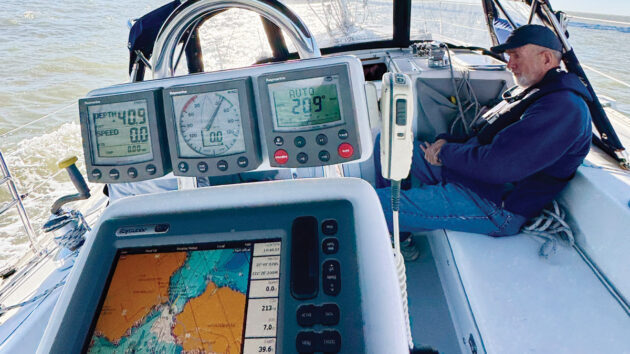
Digital gadgets on board Paul’s yacht
Old school dose
So, we instruct them on the perils of over-reliance on GPS data, how to ensure they are working from the compatible chart datums, limitations of radar information, the use of the AIS for ship identification and navigation, and how to communicate emergencies and for convenience using DSC.
With me, they also get a dose of the old school.
My caution with the new stuff runs as deep as my belief in the old ways.
Modern electronics were just becoming available for civilian use in the 1970s.
By the 1980s, the advent of microprocessors, advanced electronic circuitry, and miniaturisation of parts meant that small boat operators could begin to avail themselves of the growing panoply of technological goodies available to commercial and military vessels.
LORAN-C and radar became affordable to many civilians, but for a lot of us still operating on a limited budget, we were relegated to salivating at the storefront windows of the local chandlery.
GPS was made available for civilian use in 1983.
As electronic charts had been developed from the early 1980s chartplotters or their modern upgrade, the multifunctional display (MFD) was developed to use the new systems, and by the mid-1990s had become affordable.
Chartplotters broke onto the shipping scene in the early 2000s with the advent of the ‘electronic chart display and information systems’.
This ECDIS system became mandatory for new-build ships regulated by the International Maritime Organization (IMO) as of January 2011.
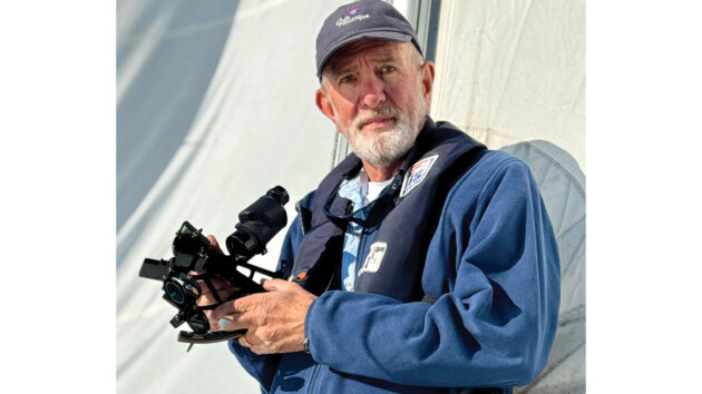
Paul recommends taking full advantage of the “fantastic array of electronic navigation equipment” but verify using your senses and traditional methods
The future
AIS jumped onto the scene just before DSC, but both use VHF and are now clogging the airwaves.
For this reason, the IMO is advancing the VHF data exchange system (VDES) and it’s coming to a device near you.
This is a two-way communication system that will allow for shore stations, ships, and satellites to communicate as an extension of the AIS system about such things as engine status, smart buoys, and more.
This new technology will roll out over a 10-year period starting in 2025 under the auspices of the IMO’s e-Navigation strategy.
If that’s not enough of a tangled web, some manufacturers have put AIS into VHF radios.
To be honest, having a handheld radio with a smartscreen showing AIS targets sounds pretty good.
Innovations have happened quickly and MFDs now typically integrate GPS, depth sounders, AIS, and radar.
Plus, they’re enabled with wifi and Bluetooth.
With the advent of open-source chart software such as OpenCPN, many sailors are adding a GPS dongle to a laptop to get a backup system – and one that’s good for route-planning with weather integration as well.
It’s common these days to have a laptop running chart software to create routes and waypoints from the comfort of the living room with paper charts, Sailing Directions, and Coast Pilots at hand – maybe even with a glass of port and a fire crackling in the corner.
Once satisfied, the work can then be transferred to a chartplotter.
That process works in the other direction too, so routes, tracks and waypoints can be taken off an MFD and put on a laptop for further processing and consideration.
But all of these bells and whistles don’t replace common sense and human judgement.
While the number of large ship collisions is down 50% from 10 years ago according to Allianz, the number of accidents due to electronic navigation errors (and alcohol) on smaller vessels remains high.
Many users of electronic charts remain unaware of chart datum errors, the perils of overzooming, and the false sense of security provided by a blip on a screen.
I tell my GRAD students about a time when I was leading a coastal passage trip that took place in thick fog and windy conditions.
I let the student-navigator have a go at a narrow channel leading up to Drake Bay from San Francisco.
Feeling uneasy, I pulled my handheld GPS from my jacket while sitting on the aft seat of the cockpit only to find out the boat had started to drift dangerously toward the rocky lee shore.
GPS only confirmed what the changes in sounds, birds, and wave form were yelling at me: namely, trouble ahead.
The student-navigator, glued to the chart table, not only relied solely on GPS, but he hadn’t bothered to stick his head outside of the nav station in a long while.
I also tell students that no one says they have to keep barrelling ahead toward danger in a dead-sweat panic while staring into the chartplotter.
Don’t rely on a single source of data
The online report of the grounding of Vestas Wind in November 2014 provided by an independent team for the Volvo Ocean Race sponsors underscores this point:
“Safe navigation depends upon continually checking different sources of information and, if they do not agree, finding out why. In a harbour this can be a simple check that what you are seeing with your eyes confirms what is displayed on a chartplotter. There is always a risk if the navigator relies on a single source of data. In preparing major passages most electronic chart presentations should be checked against the paper charts and the Sailing Directions.
“Unfortunately, the attractive presentation of electronic data creates a misplaced air of confidence in the accuracy of what is presented. There can be a false sense of security and a belief that further checks are not necessary. This can be a mistake.” (The Vestas Wind Report, Version 1.2, by Chris Oxenbould, Stan Honey and Chuck Hawley, 31 January 2015.)
A leading manufacturer’s description of a new radar system says you can ‘navigate with augmented reality’ with their product. I really hope they are kidding.
What would Slocom or Moitessier think?
I worry this generation of mariner will feel like they are going around on some kind of hologram deck with something akin to a virtual reality visor on – and will miss the thrill of navigation without all this fancy stuff.
It was so engaging to navigate by integrating human senses with the few basic tools we had.
Finally, I tell students that when things are getting dicey, it’s time to use all six senses.
Get on deck with an unobstructed view ahead, sniff the air, and look around.
If something does not feel right, it’s time to stop or heave to.
That will calm things down, both in terms of the boat’s motions and the crew’s emotions.
These valuable minutes can provide time to determine what to do next.
Sometimes that means going backwards on a reciprocal course, retracing your steps into safe water.
Electronic navigation versus traditional methods? – Embrace the best of both worlds
- Trust but verify. Take full advantage of the fantastic array of electronic navigation equipment, but also use all of your senses.
- Spend time in the cockpit or on deck assessing and enjoying your environment. Check your observations of the real world against the information on your electronic navigation devices.
- Have multiple backups to the multifunction display or chartplotter on your vessel. A laptop with a GPS receiver running a program like OpenCPN can be either a great backup or primary navigation device (with the ship’s chartplotter or MFD as backup).
- Exercise caution when using auto-routing on modern navigation programs. It is not infallible. Check data against other sources.
- Always ‘walk the route’ you create while zooming in and out on the chartplotter to ensure you know where all the hazards are and how to avoid them. Don’t stay in one level of zoom while under way either – zoom in and out to check your surroundings.
- Radar is your friend. Use it in chart overlay mode to distinguish between vessels and other objects. Use radar for collision avoidance and navigation. When used in conjunction with AIS to identify vessels in your vicinity, it becomes a powerful tool.
About the author

Paul Jones is based in California, USA, and has been a sailing instructor for over 40 years, including two seasons at Les Glénans, France.
He held a 100-ton US Coast Guard Captain’s License for 30 years, teaching in San Francisco Bay.
He currently teaches celestial navigation and electronic navigation courses and is on the national navigation faculty for US Sailing & US Powerboating.
Expert comment from a Royal Institute of Navigation (RIN) spokesman

Paul Bryans, chair of the Small Craft Group of the Royal Institute of Navigation (RIN) and an RYA Yachtmaster examiner
Paul Bryans, the chair of the Small Craft Group of the Royal Institute of Navigation (RIN) and an RYA Yachtmaster examiner, responds:
I read Paul Jones’s article with interest, he only beat me to offshore sailing by one year! Astro-navigation still has its place, even if only used as a backup, and I write this having just returned from examining a German candidate for his RYA Yachtmaster Ocean ticket.
Astro skills have always been a requirement for ‘unlimited’ qualifications in the UK from the MCA/RYA.
RIN will be releasing an update of our Electronic Navigation Systems booklet this summer (by free download from the RIN website: rin.org.uk/page/ENav) which will include a new chapter on electronic means of sight reduction; possibly the best example of mixing traditional navigation techniques with modern electronic systems!
In the UK, the RYA syllabi for their courses are different from the US Sailing model and are now embracing ‘digital first’ as the shorebased teaching method.
Paul is correct to highlight that leisure accidents remain high while commercial shipping accidents have declined.
Why is that? Complacency and lack of training or understanding is probably the explanation.
A navigation app on your phone is very seductive and electronic systems have both opened boating to a new market but also led us to assume that training is not required; that navigation afloat is just like using a navigation system when driving. It is not.
Training has never been more important, which Paul correctly points out.
The key requirement for all skippers and navigators at sea has always been to use all available information, not just one source.
How would you navigate to safety if your onboard electronics failed? As in most situations, we should hope for the best but be prepared for the worst and have a suitable backup navigation means.
Electronic navigation systems and electronic charts used on leisure vessels are currently ‘not approved for navigation’ by any authority, something which the Pleasure Vessel Navigation Systems Working Group (which I chair) is about to report on to the MCA.
The group’s aim is to define some sensible improvements which should make the charts and systems (both installed chartplotters and mobile device apps) safer and easier to use.
We are moving towards a digital future so the electronic systems must be robust and useable for navigation without a GNSS fix.
Send us your boating experience story. If it’s published you’ll receive the original Claudia Myatt-signed watercolour, which is printed with the article. Email pbo@futurenet.com
Basic survival celestial navigation
Making a ‘mer pass’ observation is one of the simplest, yet most useful navigation tools for sailors to possess, explains…
Celestial navigation books: Best guides to navigating by the sun and stars
I have always considered the ‘noon sight’ to be something romantic and intellectually interesting. Having learned from books how to…

Best sextants: 5 plastic options under £400 for taking a noon sight
In the mid-seventies I sailed a small boat from the UK to Tahiti, crossing the Atlantic, Caribbean and Pacific. My…
Want to read more Learning from Experience articles?

A subscription to Practical Boat Owner magazine costs around 40% less than the cover price.
Print and digital editions are available through Magazines Direct – where you can also find the latest deals.
PBO is packed with information to help you get the most from boat ownership – whether sail or power.
-
-
-
- Take your DIY skills to the next level with trusted advice on boat maintenance and repairs
- Impartial, in-depth gear reviews
- Practical cruising tips for making the most of your time afloat
-
-
Follow us on Facebook, Instagram, TikTok and Twitter